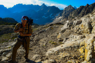
Grand Teton National Park is hands-down glorious. The front country alone will take your breath away with its dramatic appearance from the ground. Its towering and unique presence comes from the lack of foothills on the east side of the mountain range. Then there’s the backcountry. It’s pure magic back there with huge sweeping landscapes where you can look down deep valleys for miles and up at intense passes that will make you hungry to know what’s next. If you’re looking to satisfy that hunger, follow these ten steps to planning your Teton Crest Trail adventure.
The Teton Crest Trail is a 40-mile (64 km) long hiking trail that extends from Phillips Pass, on the border of Bridger Teton and Caribou-Targhee National Forests, to String Lake in Grand Teton National Park. Backpacker Magazine calls the Trail one of the “Best Hikes Ever,” with “mesmerizing and constant views of jagged peaks.”

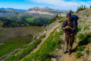
Beginning in the south, the Teton Crest Trail can be accessed in several ways. From inside the National Park, the Granite Canyon Trail provides a gradual ascent into the Range, where it connects with the TCT. The Trail is most easily accessed by riding the Jackson Hole Aerial Tram, which transports sightseers and hikers from the Teton Village Resort to the top of Rendezvous Mountain. From outside the Park, the Teton Crest Trail can be accessed via the Phillips Pass Trail, one of several routes through adjacent National Forest lands.
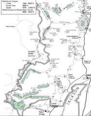
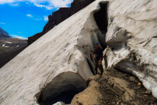
Continuing from the south, it is a 32-mile (51 km) trek to String Lake, passing in and out of Bridger-Teton National Forest twice, traversing the Death Canyon Shelf and several high passes including Mount Meek Pass, Hurricane Pass and Paintbrush Divide. It is a challenge with 9,681 feet total ascent and 10,779 feet total descent. The trail also traverses the high alpine meadows of Alaska Basin in the Bridger-Teton National Forest. From Hurricane Pass, the trail provides easy access to Schoolroom Glacier, and parallels the west side of major peaks of the Cathedral Group as it follows the North and South forks of the Cascade Creek.
One of the best routes on the Crest Trail is from Death Canyon to Static Peak Divide to Cascade Canyon. It’s about 25-miles and it hits Alaska Basin and Hurricane Pass.

In the Tetons, you must be prepared for a variety of conditions depending on the time of year. Up until late July / early August, snow often remains in the high country and on mountain passes. If you are hiking the trail in June or July (before the snow fully melts) or in mid-to-late September (when snow can begin to fall again), you will want to consider bringing microspikes/crampons and an ice ax. If the trail is clear of snow, then these are not needed.
Because of rapidly changing weather in the mountains, you will want to bring several layers so that you can easily adapt to the changing temperature and also so that you can stay dry. I also recommend having a set of wool clothes to change into at camp. Wool is great because it doesn’t pick up funky stenches as fast at cotton or synthetic clothes. It also dries out quickly so that you are able to stay warm even if all your gear gets soaked in a thunderstorm.
The Grand Teton Mountains are home to moose, deer, elk, bighorn sheep, black and grizzly bears, mountain lions, wolves, and many other species.
Other specific gear you will want for backpacking in Grand Teton National Park is related to bear safety. The park is inhabited by both grizzly and black bears. Thus, it is essential to store all food and scented items in a bear canister. It is also highly recommended for every member of your party to carry bear spray. Bear canisters are required in the backcountry and carrying bear spray is encouraged.
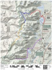
There are 11 campsites along the Teton Crest Trail. Once permits are secured and you’re on the trail, all individual sites are first-come, first-serve within each zone for parties of six or fewer people. For more information on backcountry campsites, visit the NPS site. Group campsites may only be used by permit-designated groups (more than six people) specifically assigned to them, and marked with signage.
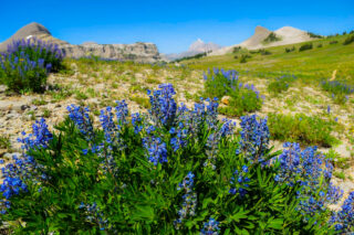
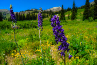
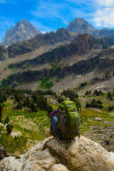
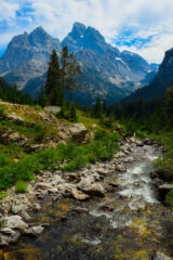
The Teton Crest ranks high on lists of the country’s best backpacking trails. The trip is jam-packed with stunning views of the Teton Range, glacier-carved valleys, glistening lakes and wildflower-fill meadows. The backpack travels through the heart of the Teton Range, climbing over high passes and traversing scenic valleys and high benches along the divide. Almost everyday features iconic views of the range’s majestic granite peaks.


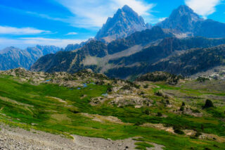
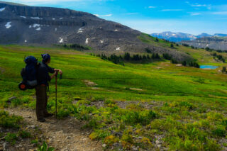
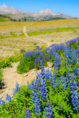
We have been fortunate to backpack this stunning trail in the past over 2, 5 days. Starting on Day 1, parking our car at our hike out location – near Jenny Lake. Using local shuttle service, we got picked up near Jenny Lake and shuttled to the start point of our hike – Granite Canyon Trailhead. We have started our hike around 7am. The first several miles are in the canyon hiking through meadows, forest until the trail reaches Marion Lake. A granite cliff towers above the west side of the lake. The bench is clad in beautiful meadows, filled with wildflowers in late July, and clusters of trees. The small backcountry campsite is situated to the east of the lake. The hike is long and not very scenic. Next time we will most likely opt to take the Aerial Tram from Teton Village to start this hike at the summit of Rendezous Mountain (10,455-ft.) From the overlook the summits of Grand Teton, Middle Teton, South Teton and Mount Wister are visible above Mount Hunt (10,783-ft.) along with the unnamed summits towering above the north side of Granite Canyon. Fossil Mountain and Mount Bannon rise above the ridge above Death Canyon Shelf to the northwest. Jackson Hole, Jackson Lake and the Gros Ventre Mountains dominate the views to the east/northeast. Rendezvous Peak (10,927-ft.) towers above the valley floor to the south.
The Teton Crest trail travels along the eastern shore of Marion Lake and then curves to the north, traveling through pretty meadows as it ascends to a saddle atop the Continental Divide. You are now out of the park and walking in the Jedediah Smith Wilderness in Targhee National Forest. The trail descends across a broad bench, wandering through lovely meadows on easy grades. South Teton, Middle Teton and Grand Teton dominate the view to the northeast. Spearhead Peak rises above the plateau to the east. Fossil Mountain towers above the head of the Fox Creek Valley. The trail soon crosses Fox Creek Pass (9,600-ft.) and then ascends to a junction with the Death Canyon Trail. You have now crossed back into the park. We continued straight ahead on the Teton Crest Trail. Ahead are amazing views of the rugged cliffs towering above Death Canyon Shelf, a bench clad in beautiful meadows. Peaks rising along the ridge from south to north are Fossil Mountain, Mount Bannon, Mount Jedediah Smith and Mount Meeks.
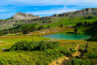
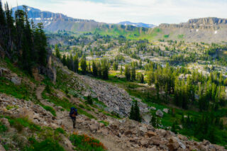
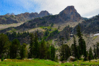
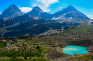
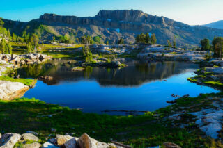
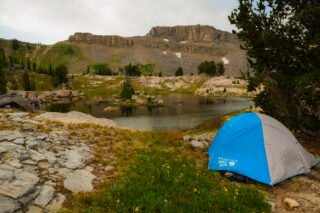
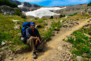
After a brief ascent the trail traverses the shelf on an undulating trail, passing several nice campsites. Views stretch northeast to the high peaks of the Teton Range. To the east Prospector Mountain, Peak 10,988 and Peak 10,905 tower above Death Canyon. At the northeast end of the shelf the trail climbs on moderately-easy grades to Meeks Pass (9,726-ft.).. Mount Meeks (10,681-ft.) rises above the pass to the west. A sign at the pass marks the boundary for Grand Teton National Park. You are now back in the Jedediah Smith Wilderness in Targhee National Forest. The first day topped at 18 miles, and we decided to camp at the Alaska Basin. Eight scenic lakes lie nestled amid granite knolls, meadows and scattered trees in the gorgeous basin. The easiest access to the basin is via the South Fork trail. Use trails along the South Fork lead to various camping area. Please remember to choose an established site and camp at least 200-ft. away from water sources. Alaska Basin is a great place to camp, although it can get quite crowded. Bears frequent the basin, so make sure you food is secured on a bear canister, which you must carry anyway if you are camping along the Teton Crest trail in the park. I would suggest to arrive in Alaska Basin early in the afternoon to secure a good site. This will leave you time to hike the scenic South Teton trail ascending to Static Divide Pass (10,790-ft.), a saddle on the ridge to the south of Buck Mountain (11,938-ft.).

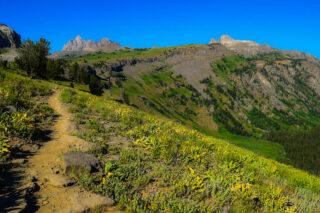
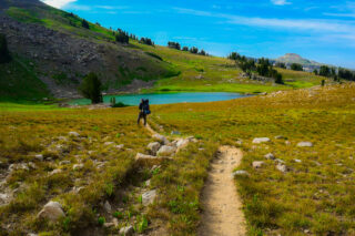
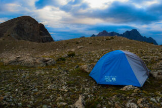
Day 2 starting bright and early, heading up Hurricane Pass (10,400-ft.). South, Middle and Grand Tetons dominate the views to the east. To the northeast are the peaks rising along Cascade Canyon. Mount Moran (12,605-ft.) in the distance. From the pass the trail turns northeast, descending on moderately-steep switchbacks to a bench scattered with small tarns. The Schoolroom Glacier clings to the slopes to the south. Moraines dam the meltwater pond at the foot of the glacier. To the east are stunning views of Grand, Middle and South Tetons. The steep descent soon resumes as the trail drops down a series of benches. The trail curves to the north and continues down the canyon. Ahead are fine views of the peaks rimming the west side of South Fork Canyon. Near the foot of the canyon views open to a pretty waterfall tumbling down the steep slopes below Grand Teton. Here the South and North Fork of Cascade Canyon meet. The trail to the east heads down the main fork of Cascade Canyon to the boat dock at the foot of the Canyon. (This is a good escape route if severe weather is threatening or your party has run into difficulties.) Now we are heading on the North Fork of Cascade Canyon toward Lake Solitude and Paintbrush Divide. The path now climbs through trees on moderate grades, crossing a wood bridge to the east side of the canyon. As you climb the trees give way to pretty meadows with ever improving views of the glacial valley, rimmed by rugged granite peaks. Turn around to the south for breathtaking views of the Cathedral Group; Teewinot Mountain, Mount Owen and Grand Teton, towering above the foot of the valley. From Lake Solitude the trail heads steeply up the Paintbrush Divide. The ascent enjoys terrific views of Lake Solitude, Mount Owen, Grand Teton, Middle Teton and South Teton. With binoculars or a zoom lens you should be able to see across Hurricane Pass to the high peaks towering above the Teton Shelf. Reach wind swept Paintbrush Divide (10,715-ft.). Woodring Mountain rises to the east. Mount Saint John and Rockchuck Mountain tower above Paintbrush Canyon to the southeast. Due to a storm chasing us, we opted to pitch our tent on the top of the ridgeline and wait out the night. It was getting late in the day and as we originally thought we might hike out that evening, we decided to stay another night.


On Day 3 the sun returned as we descended steep switchbacks down the east side of the pass. Views soon open to Mount Moran and Thor Peak towering above Leigh Canyon to the northeast. Beyond the switchbacks the moderately-steep descent continues down the rugged canyon. Soon views open to a small pond nestled in the talus slopes below the canyon’s south ridge. Beyond Holly Lake the descent down Paintbrush Canyon continues on moderately-steep grades, traveling through trees and talus slopes. As you descend views open to Jackson Lake to the east. Soon we reached Jenny Lake Trail and around 10am we were by our car and drove out of the park to nearest restaurant for hot meal and soda.
Overall, I think of Teton Crest trail with love and fondness and recently started to planning our return to these majestic mountains.

Permits:
Advanced backcountry camping reservations are available via recreation.gov. The park currents reserves one-third of the sites in each camping zone. The remainder of the camping zones are allocated on a first-come, first serve permit in person one day before the start of the backpacking trip. There is very high demand for the walk-in permits during the height of the summer. Check the Teton National Park website to determine the window for making advanced reservation system.
If you’d rather take a chance on a walk-in permit, your chances are fair. The park service reserves up to one-third of each camping zone (see maps) in advance and the remaining two-thirds are released for walk-in permits, which are available on a first-come, first-served basis one day before the start of a backcountry trip. No walk-in permits are available for same day starts, and keep in mind that during peak backcountry season (July and August), competition is stiff. We recommend having a backup plan if you choose the walk-in option.
Note: All persons camping in the park’s backcountry are required to use Interagency Grizzly Bear Committee (IGBC) approved canisters for food storage. Canisters may be checked out for free when you pick up your permit. Visit the IGBC website for a list of approved bear containers.