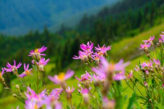
Glacier Peak is one of the five volcanoes of the state of Washington, and is the highest mountain in Snohomish county. It has 7498 feet of prominence and ranks 5th highest on the Bulgar List (Washington Top 100). It is located in the North Central part of the Cascades which it has a wilderness named after this mountain which is called the Glacier Peak Wilderness. The Native Americans once called this peak Takobia which would translate to “The Great Parent”. This peak is classified as a stratovolcano, which there has not been any major activity in 300 years. This peak goes unnoticed by much of the people of the Northwest due to it being so far in the crest of the Cascades, its distance from the nearest town, and the fact that its access roads have been washed out making all the approaches to its base a long hike in. Glacier Peak can be seen from many locations along the Mountain Loop Highway, North Cascades, Highway 2 area, and many other high points through out the state. But this peak is often hidden from view from many low land areas which is another big reason it goes unnoticed by many. The summit offers amazing views of many of the great peaks of Washington, as well as a view of seeing far across the state.


Evidence of volcanic activity is clearly visible in the pyroclastic flows, ash deposits, and multiple hot springs. As Washington State’s most remote volcanic peak, Glacier Peak is completely surrounded by wilderness. Access requires at minimum 10 miles of hiking just to reach a “base camp”.
Dakobed is the most isolated of the five major stratovolcanoes of the Cascade Volcanic Arc in Washington.
Glacier Peak and Mount St. Helens are the only volcanos in Washington State that have generated very large explosive eruptions in the past 15,000 years. During some of these eruptions, Glacier Peak erupted massive volumes of volcanic ash that was blown eastward by winds.
Known as “Dakobed” in the language of the nearby Sauk Indian Tribe, Glacier Peak stands alone in the Glacier Peak Wilderness. It is the most isolated of the five major Washington State volcanoes, a massive, tantalizing objective visible in the distance from Mount Baker, Mount Rainier and other Cascade peaks.


Eleven significant glaciers cover Glacier Peak. When C.E. Rusk first saw these glaciers in 1906 they were beginning to retreat, but were still very advanced. The average retreat of Glacier Peak glaciers from the Little Ice Age to the 1958 positions was 5,381 feet. Richard Hubley noted that North Cascade glaciers began to advance in the early 1950s, after 30 years of rapid retreat. The advance was in response to a sharp rise in winter precipitation and a decline in summer temperature beginning in 1944. Ten of the fifteen glaciers around Glacier Peak advanced, including all of the glaciers directly on the mountain’s slopes. Advances of Glacier Peak glaciers ranged from 50 to 1,575 feet and culminated in 1978. All eleven Glacier Peak glaciers that advanced during the 1950–79 period emplaced identifiable maximum advance terminal moraines. From 1984 to 2005, the average retreat of eight Glacier Peak glaciers from their recent maximum positions was 1,017 feet. Milk Lake Glacier, on the north flank of the mountain, melted away altogether in the 1990s.
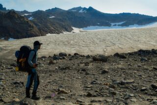


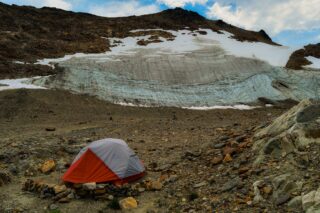
From Sloan Creek Campground, we followed Trail 649 along the North Fork of the Sauk River. After 5.5 miles, we reached the Mackinaw Shelter Camp. We continued on Trail No. 649 up switchbacks for roughly 2,500 vertical feet until a rising traverse takes us to White Pass, just below its intersection with the Pacific Crest Trail. We made camp at 5,900 feet.
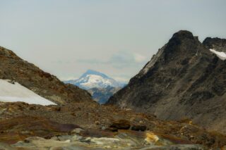
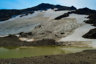
From White Pass, we followed the Foam Creek Trail on an ascending traverse under White Mountain. We left the trail and headed up to the Eastern Col at about 6,600 feet, where we enjoyed our first views of Glacier Peak. A 400-foot descending traverse leads to low-angle terrain that took us up to the former edge of the White Chuck Glacier at roughly 6,700 feet. Numerous campsites are available here on flat snow, but we continued north across the former bed of the White Chuck Glacier to our high camp at the col on the edge of the Suiattle Glacier at 7,300 feet.
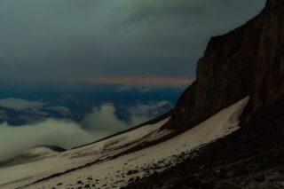
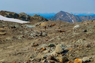
From here we descended 100 feet to the nose of the Disappointment Cleaver and the beginning of our climbing route to Glacier Peak’s snowy summit. From high camp, we climbede moderate snowfields around Disappointment Peak to the Cool Glacier. We ascended the Cool Glacier, eventually traversing a snow and rock arête before stepping onto Glacier Peak’s summit. From the summit, we enjoyed panoramic views of the Glacier Peak Wilderness, Mount Baker, Mount Rainier and the peaks of the North Cascades. We descended to high camp, packed our gear and continue back to our White Pass camp for the evening.
After breakfast, we broke camp, packed our gear and retraced our steps back to the trailhead.